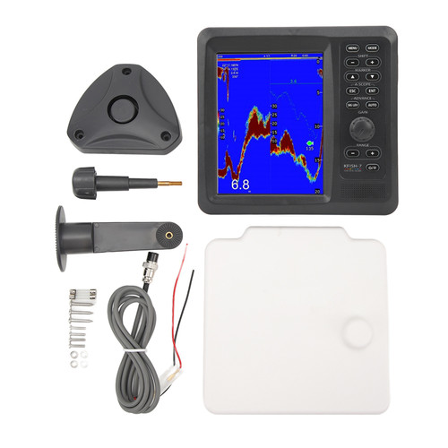
Product Overview
Condition: Brand New
Item Type: Marine GPS
Material: ABS
Color: As picture shown
Reference ID: 183767515570
Plotter Specifications
1. WAYPOINTS/ ICONS
12,000 user waypoints with name, symbols,
3 system waypoints: MOB,Start,cursor
10 proximity waypoints
2. ROUTES
Maximum: 30 routes and up to 170 points for each one
3. TRACKS
8,000 point automatic track log; 10 saved tracks (up to 8000 track points each). Lets you retrace your track in both directions
4. ALARMS
XTE, Anchor drag, arrival, speed, voltage, proximity waypoint and time,AIS alarm.
5. PALLETE
Normal
Daylight exposed to sunlight
Night in dark environment
NOAA paperchart colors
6. TIDES
For Tide data
7. PROJECTION
Mercator projection
8. POSITION FORMAT
Degree of minutes and UTM
9. BASEMAP
Built-in Onwa K-Chart
10. EXTERNAL MAP
Memory Cards slot for C-Map Maximum and for ONWA K-Chart
11. USER DATA STORAGE
Internal backup of user settings
12. For PLOT INTERVAL
5s to 60min. 0.01nm to 10nm
Automatic way
13. PLOTTING SCALES
0.001nm to 1,000nm
14. NAV DATA
Inputs:
$–GGA, $–GLL,$–GSA, $–GSV,$–RMC,
$–VTG, $–ZDA, $–VWR,$–VWT,$–MWD, $–VPWOutputs:
GGA,GLL,RMC,AAM,APA,APB,BOD,
BWC, BWR,DBT,DPT,HDT,MTW,RMB,
TLL,VTG,WPL,XTE,ZDA,ZTG,ZDL,MWD,
VPW,VWR,VWT
Outputs for autopilot:
$–APB,$–BOD,$–XTE,$–APA
15. PERSPECTIVE VIEW
On/off
16. For CELESTIAL
Sunrise/Sunset Moonrise/Moonset
POWER SUPPLY
10.5 to 35VDC, current drain<1.0A at 12V
Item Type: Marine GPS
Material: ABS
Color: As picture shown
Reference ID: 183767515570
Plotter Specifications
1. WAYPOINTS/ ICONS
12,000 user waypoints with name, symbols,
3 system waypoints: MOB,Start,cursor
10 proximity waypoints
2. ROUTES
Maximum: 30 routes and up to 170 points for each one
3. TRACKS
8,000 point automatic track log; 10 saved tracks (up to 8000 track points each). Lets you retrace your track in both directions
4. ALARMS
XTE, Anchor drag, arrival, speed, voltage, proximity waypoint and time,AIS alarm.
5. PALLETE
Normal
Daylight exposed to sunlight
Night in dark environment
NOAA paperchart colors
6. TIDES
For Tide data
7. PROJECTION
Mercator projection
8. POSITION FORMAT
Degree of minutes and UTM
9. BASEMAP
Built-in Onwa K-Chart
10. EXTERNAL MAP
Memory Cards slot for C-Map Maximum and for ONWA K-Chart
11. USER DATA STORAGE
Internal backup of user settings
12. For PLOT INTERVAL
5s to 60min. 0.01nm to 10nm
Automatic way
13. PLOTTING SCALES
0.001nm to 1,000nm
14. NAV DATA
Inputs:
$–GGA, $–GLL,$–GSA, $–GSV,$–RMC,
$–VTG, $–ZDA, $–VWR,$–VWT,$–MWD, $–VPWOutputs:
GGA,GLL,RMC,AAM,APA,APB,BOD,
BWC, BWR,DBT,DPT,HDT,MTW,RMB,
TLL,VTG,WPL,XTE,ZDA,ZTG,ZDL,MWD,
VPW,VWR,VWT
Outputs for autopilot:
$–APB,$–BOD,$–XTE,$–APA
15. PERSPECTIVE VIEW
On/off
16. For CELESTIAL
Sunrise/Sunset Moonrise/Moonset
POWER SUPPLY
10.5 to 35VDC, current drain<1.0A at 12V
Features
1、7‑inch GPS chart plotter with Class B AIS transponder.
2、7 inch LCD, high resolution (800 x 480 pixels) , easy to read.
3、Support dual mapping system: K‑Chart and C‑Map.
4、Supports the latest for ONWA KChart 3.0.
5、IPX5 protect grade, which is dependable to use.
Package List
1 x 7 Inch GPS Navigator
1 x Panel Protection Plate
1 x GPS Antenna
2 x Fuse
3 x Screw
1 x Mounting Bracket
1 x Power Cord
1 x Instructions
Package Weight and Dimension
| Weight | 3.61 lb |
| Width | 7.02 Inch |
| Height | 6.63 Inch |
| Length | 10.14 Inch |